Breakable Crust
23rd February 2016
Mixed weather today with sun, cloud, snow and wind all experienced at some point. Slopes that were exposed to the sun yesterday now have a breakable crust in many places, which generally doesn’t support someone on foot but mostly supports a skier. With a similar forecast for the next few days this crust should become more supportive especially in the morning before the sun gets to it. By the weekend we might have spring snow which is great to ski if you get your timing right and catch it as it starts to soften in the sun.
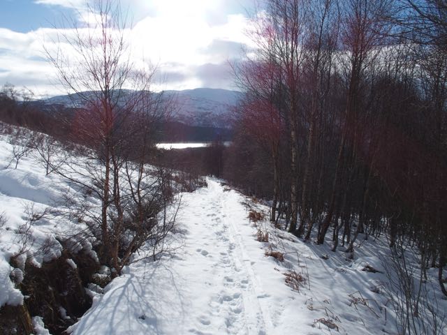
Skinning through the birches.
Lots of snow in any sheltered area.

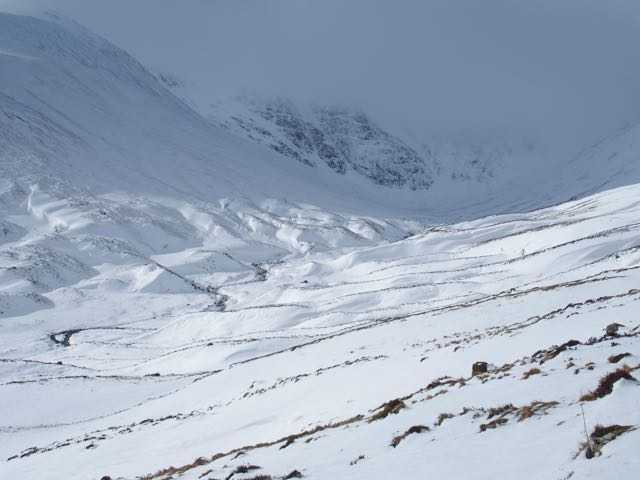
Looking into Coire Ardair at one of the clearer moments.
Comments on this post
Got something to say? Leave a comment


Grant Duff
23rd February 2016 6:10 pm
The high hazard continues. This must be the longest period of high rating since reporting began at Creag Meagaidh.
David
23rd February 2016 6:21 pm
I see Grant’s comment. I’ve been following the SAIS blogs almost for as long as it’s been operating. How far is the SAIS ‘erring on the side of caution’ since the high number of casualties in the Scottish hills at the start of 2013? Or has this (genuinely) been a particularly ‘heavy snow / high avalanche risk’ winter season so far?
BTW – really enjoying the Meagaidh blog…and good banter about the Torridon folk the other day
meagaidhadmin
24th February 2016 10:05 am
Thanks for your comment David. SAIS are certainly not consciously erring on the side of caution. The Hazard rating is however for the aspects with the highest hazard and there are usually other aspects and elevations that are safer. The early part of this season saw cycles of heavy snow and very warm wet periods giving fairly rapid changes to the avalanche hazard. There is currently a lot of unstable snow on the hills and the temperature is fairly low which means that the hazard level is not changing quickly. This weather pattern is due to continue for the next few days at least so I’d expect this period of increased hazard to continue.
SAIS produce an annual report for each season which usually includes the number of days at each hazard level and compares this to previous seasons. http://www.sais.gov.uk/sais-annual-reports/ It will be interesting to compare this season.
meagaidhadmin
24th February 2016 2:02 pm
Hi David,
Many thanks for your comment. Good to hear from you again and glad you continue to enjoy the blog.
Brian has beaten me to a reply! I donât think what follows runs counter to whatâs already been written but I hope it elaborates on it a bit (â¦maybe at too much length!)
Has this winter been a particularly snowy/higher hazard winter?
Dealing with the current winter, the simple answer is yes. The weather has been appalling in much of the northern Britain so far this winter with many well-documented stories of flooding and high winds acting as testament. Scotland has had more than its fair share of this extreme weather too. Snowfall may not have been exceptional but, to date, that would certainly be the case for wind speeds (loading of lee slopes) and rainfall amounts (a trigger on new snow) weâve had. Add in a couple of periods of cold clear weather to get some buried weak layers started and you end up with quite a toxic mix leading to instability and elevated hazard.
âErring on the side of caution?â: Has there been a gradual shift in the way we classify hazard since 2012/13?
The answer to this is much more complicated and nuanced, delving as it does into the realms of human perception.
The simple answer to the question is no. Itâs a ânoâ because at SAIS corporate and individual forecaster level we think deeply about the potential of âcrying wolfâ when we sit down at each dayâs end to compose our reports/forecasts.
In addition, I think our avalanche forecasts have become better in the past few years due to much more detailed and, crucially, more accurate weather forecasts. Itâs difficult to believe but in the very early days of the âScottish Avalanche Projectâ (as it was first called) the weather forecasts which formed the basis of our avalanche forecasts were culled from that dayâs newspaper! Soon after we progressed to a brief phone conversation with a Met Office forecaster in Aberdeen but this is very low calibre in comparison to the hour by hour data set we now use. This recent development has been a quiet revolution for us and led to a palpable improvement in the quality and accuracy of our avalanche forecasts.
Other important factors to consider in answering your question are:
1. The loading required to trigger avalanches.
2. The âreachâ and availability of the SAIS forecasts to the mountaineering community.
3. How the mountaineering community acts upon our formal forecasts, messages about mountain conditions, hazard and stability.
Actually, the subtle interplay of the above three factors.
Every day I work for the SAIS I look at this when Iâm formulating the avalanche forecast:
http://beaware.sais.gov.uk/resources/#resource3
It tells me everything I need to know about the category I should use when deciding how responsive to loading the snowpack is expected to be the next day. Loading is critical when calculating projected stability and hazard. (Any slope above 15 degrees inclination holding snow can avalanche if the load on it is sufficient. This can vary from a single extra snow crystal at one end of the scale through to a serac fall of many thousands of tonnes at the other end.) Look carefully, particularly at the wording and âscalingâ of the Moderate and Considerable categories as one or other of these is prevalent in our mountains in winter. The same applies to all other mountainous countries where avalanche forecasts are generated.
A âConsiderableâ forecast doesnât necessarily mean there will be avalanche activity. The snowpack may be delicately poised awaiting a load to exceed a critical threshold before avalanche activity can begin on a particular slope. In these circumstances, no loading = no avalanches. But the snowpack is still nevertheless weak and the overall hazard elevated, deserving of its âConsiderableâ designation. So thatâs why youâre seeing a lot of Considerables but not necessarily a lot of avalanches. Itâs the potential of the snow to avalanche given a particular load. (Also, avalanches can occur in âModerateâ conditions, itâs just the scaling of load and instability are different.)
Of course thereâs days when itâs Considerable and we get natural avalanches due to – in very simple terms – the large amounts of new snow accumulating quickly on a slope. Here look for the words âavalanches likelyâ in the wording of a Considerable forecast. (A High category would be issued when we feel there will be natural avalanches – or very low loading required; the hazard widespread and the avalanches large.)
The ready availability of avalanche information also has a role to play in answering your question.
Uptake of our message by the mountaineering community has been little short of astonishing since the advent of our website (more so in the past few years due to the ubiquity of smart phones), and the number of hits on our blogs will soon outstrip the main website. With easy access to snow and avalanche info, mountaineers (who are much more avalanche savvy than ever before) are choosing their mountain days and venues more judiciously. With fewer people in hazardous locations during Considerable days we have lower loading and so fewer triggers. Remember, 90% of those involved in an avalanche trigger it themselves. The three avalanches involving people at Creag Meagaidh so far this season were all triggered by the victims. As American avalanche guru Bruce Tremper once said about the avalanche problem in North America, âWe know what the problem isâ¦.itâs usâ.
See how itâs all tied together?
Of course itâs anecdotal and speculative but I think thereâs something in it.
David
24th February 2016 7:41 pm
Hi – thanks very much for the comprehensive replies, especially the latter. And particularly the sentence – ‘Itâs a ânoâ because at SAIS corporate and individual forecaster level we think deeply about the potential of âcrying wolfâ when we sit down at each dayâs end to compose our reports/forecasts.’
I think the level of information on avalanche awareness and perhaps more importantly the publicised access to it, has increased substantially, even over the last few years but I think this has particularly increased since the 2013 season, where publicity through TV (Mark Diggins and others), radio and elsewhere has tried to get the messages across about the risk to life and limb of avalanches here in Scotland. I think this increased publicity has been enhanced absolutely by the predominance nowadays of folk who have smart phones.
The forecasts have to be as factually accurate as forecasters can determine them to be, given the skills of the forecaster, weather, access to the hills etc – and the hillwalker or climber must continue to be allowed to make their own decisions about what they decide to do. There must be no actual or perceived suggestion that forecasters are erring on the cautious side.
It will be interesting to see the end of season statistics.
Thanks again. And keep up the excellent work.