The angle of dangle.
11th February 2016
Still and very quiet today. On my way up Sron a Ghoire I clearly heard people in conversation on the main Coire Ardair path some 600m away. A chainsaw fired up at one point in the forest on the other side of Loch Laggan, which is at least 3km away. Very light or negligible winds down low although there had been some drifting of snow on fresh winds at higher altitudes overnight.
(Above) Skis were the preferred mode of transport today at least for the middle part of the excursion up the hill. Pretty scratchy skinning anywhere below 600m: I did well to find a filled-in burn line to follow for some of the way. Good cover above 650m (less good on scoured West aspects) with a covering of fresh snow at all levels.
 (Above) A day of contrasting light. Very occasionally bright – as above – but flat light and clag during light snowfall later in the afternoon. Skis off at this point for a wander around on foot. The photo doesn’t show it well but the gradient here is quite steep……..
 (Above) ……about 33 degrees.
An inclinometer is a handy tool when considering the potential of the terrain to produce avalanches. If you look carefully at the inclinometer you’ll see there’s yellow, orange and red zones. You need to pay proper attention to route choice when you’re in terrain that’s ‘orange’ or ‘red’ and the avalanche hazard is enhanced.
[Notice when terrain is above 45 degrees the grading becomes progressively safer. Seems counter-intuitive but snow grains reach a critical threshold beyond their ‘angle of repose’ above 50 degrees. Snow is more resistant to accumulating above this angle and just sluffs off, often as continuous spindrift. As long as your buttress route doesn’t begin or end with easier angled ramps – as most of them do at ‘Meggie – then you’re probably in safer terrain, at least when considering the threat from avalanches.]
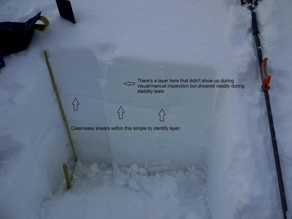 (Above) Little bit steeper at the pit site: 36 degrees. This was on a ESE aspect at 770m – quite low altitude but with instability showing up in two notable layers.
 (Above) Highly variable visibility and cloud cover during the day.
Comments on this post
Got something to say? Leave a comment


Rich
11th February 2016 9:51 pm
Great post, thanks.
Grant duff
11th February 2016 11:36 pm
The education continues. Very much appreciated.
Alistair
12th February 2016 8:31 am
Thanks for the detailed posts…..all very educational.
Lan
12th February 2016 12:41 pm
Agree with above posts – the arrows & annotations on the photos are very interesting. Wish I could be there to see for myself but failing that the extra information is great.