Goldilocks snow & Mystic Meg’s view into the future.
13th January 2023
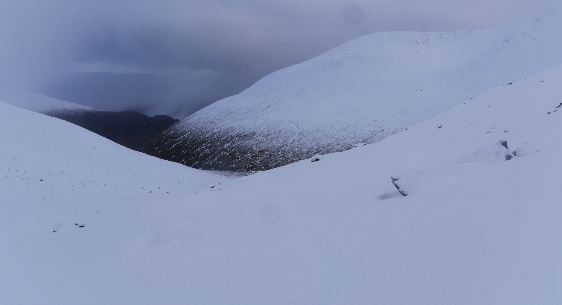 (Above) Looking out of the Inner Coire down towards Lochan a Choire – obscured – and Coire Ardair. A tour of The Inner Coire of Coire Ardair and the lower part of the Post Face today. Most of the new snow at all levels was humid, having fallen out of the sky and landing on the mountains at just sub-zero temperatures. And, a bit like Goldilocks’ experience, it was neither too warm nor too cold but just right…for a bit of early consolidation. The underlying old snow was moister and quite deep in places meaning some post-holing in the Inner Coire on the approach to The Window. Quite tiring. You’ve been warned! Fresh snow down to 650m and a well-defined snowline. If you look at the far skyline in the photo you’ll be able to make out Na Cnapanan at 625m, the micro peak above Aberarder, and a common waypoint for those en route to/from Carn Liath, one of our Munros.
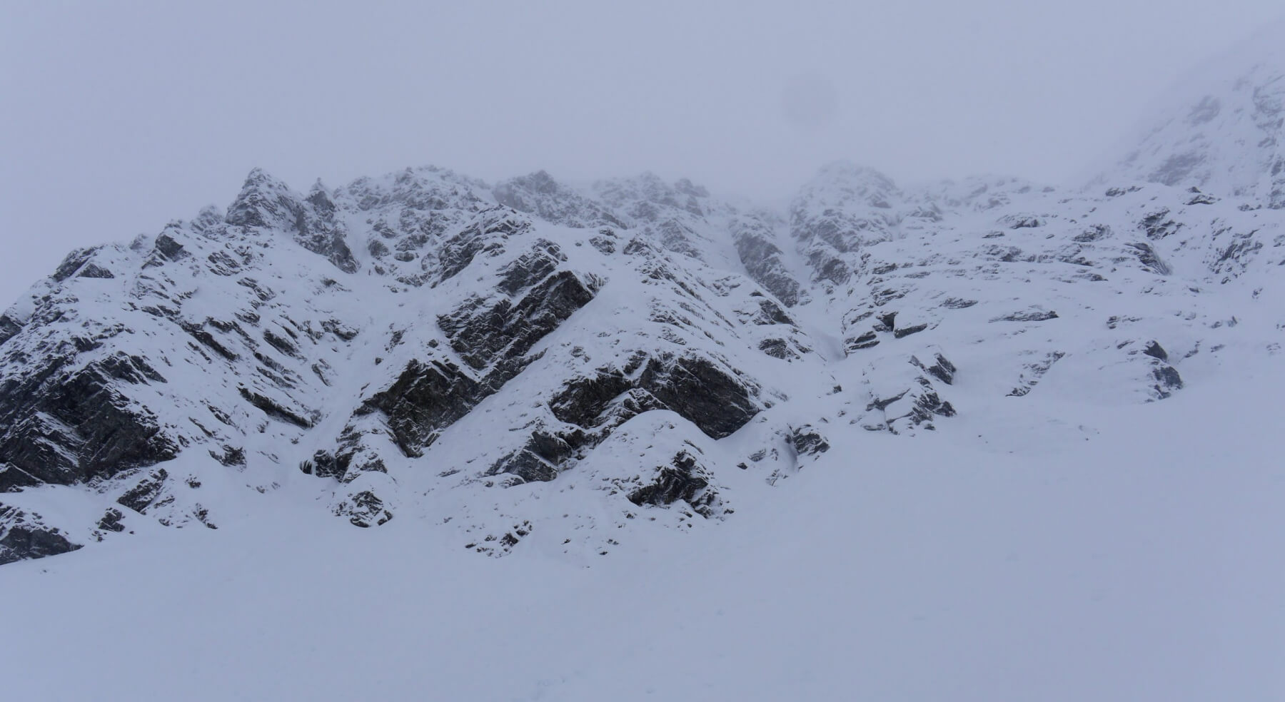 (Above) The NE facing crags of the Inner Coire of Coire Ardair. Covered in fresh snow today and a bit of a plough through deep moist old snow when ascending the crag apron. If you peer very closely at the top right corner of the photo you’ll just be able to make out a cornice line above ‘Cinderella’. Expecting more weak cornice growth here – and above other similar lee slopes – over the next day or so.
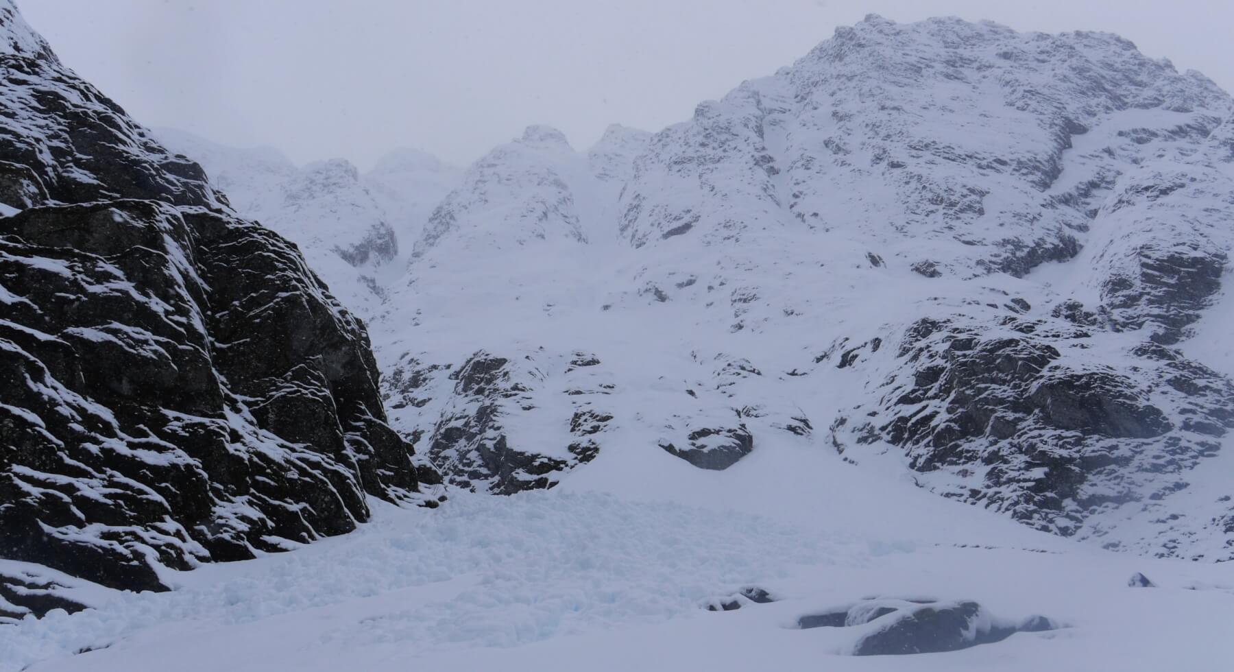 (Above) The mouth of Easy Gully and the Post Face of Coire Ardair. The avalanche debris is a few days old (and looks like it contains cornice debris, too). I think this came down from high on the Post Face itself probably from the steep ground immediately south of Last Post, one of our principal ice routes. Quite difficult moving around this snow-covered talus fan due to the snow disguising innumerable voids between rock and boulders most of which were just the right size to lose your foot and leg down.
 (Above) Looking across Pinnacle Buttress towards the mouth of Raeburn’s Gully, Eastern Corner and Bellevue Buttress. More avalanche and cornice debris here, too, this time at the base of Raeburn’s Gully; timing is probably similar to the Easy Gully events.
Goldilocks rules may have applied elsewhere but on the numerous steeply inclined shelves of the crags, the snow below the freezing level was not at all happy.
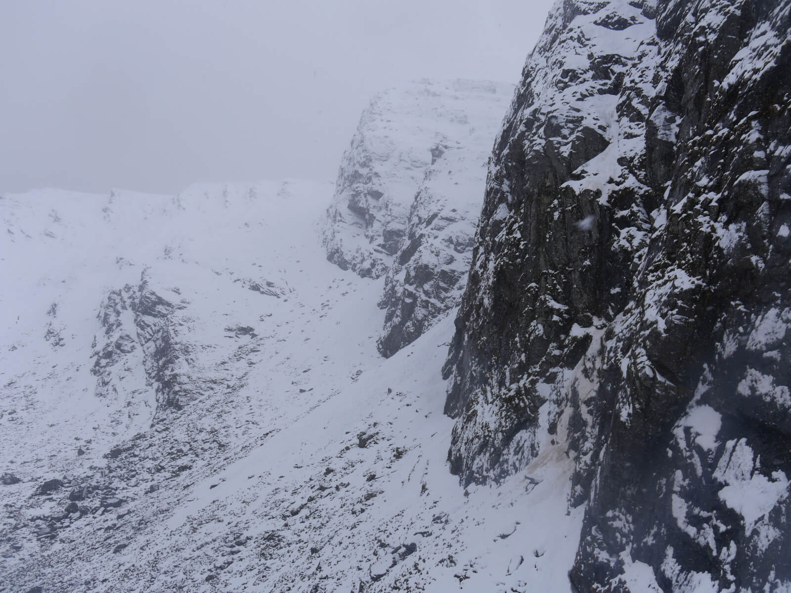 (Above) Similar shot to the previous one but includes the bay which is the start of the ‘1959 Face Route’ on Pinnacle Buttress. Note the mucky avalanche debris. This fell down at about 11.45am and was full-depth debris, albeit thin, that slid off the ramps above at about 800m – about 50m below the freezing level. So here the snow was a bit too warm (and definitely not to Goldilocks’ liking). Nor mine so I beat a hasty retreat!
Looks like we’re getting some more snow overnight on light to moderate winds. The snow already on the ground is expected to show some more consolidation but any drifting on Saturday will create new hazard on all new lee slopes. Check the formal report/forecast for details. New cornices will also be worth avoiding from both above and below.
MYSTIC MEG’S VIEW INTO THE FUTURE.
The very helpful people at the Met Office have started to provide us with a tailored weather and snow outlook, all done via a Zoom/MS Teams meeting on selected Fridays. Kudos to the Met Office and in particular to John Mitchell, one of their forecasters, for making this happen. It’s incredibly useful to us so I thought I’d share some of the info here, too.
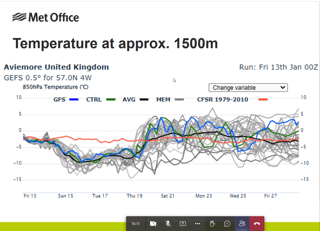 (Above) A plot of various models showing projected air temperatures for the next couple of weeks at 1500m above Aviemore, although these projections will apply (plus/minus by degree) to other parts of the Highlands as well. It’s a 14-day outlook so the usual caveats but there’s more certainty about what’s happening next week which will be much colder, in particular from Monday to Thursday. Not only that but….
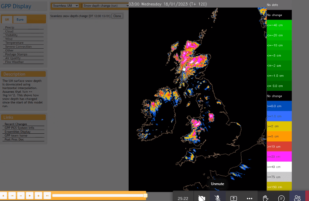 (Above) Projected accumulated snow depths (ignoring drifting) by Wednesday 18th Jan. I wouldn’t take the snow depths too literally (at all..) but it does indicate we’re in for a much more wintry few days from late Sunday onwards.
Comments on this post
Got something to say? Leave a comment


Keith Horner
13th January 2023 7:39 pm
Fascinating to see how practical experience, onsite observations and modern technology are combining to help understand how the snowpack is likely to develop over the new few days/week. Interested to hear how you are able to differentiate between avalanche and cornice debris, particularly if it’s come down hundreds of meters of cliff together…
My experience is to avoid cornices from any direction as it’s mostly likely to end in tears…!
meagaidhadmin
13th January 2023 8:40 pm
Cornice or avalanche debris? Good question, Keith. “Generally speaking”, in the Scottish context, avalanche debris is composed of smaller chunks (fist to head sized) and cornice debris is much larger – as much as a cubic metre, sometimes more. More often than not cornices, due to the way they formed, are composed of dense sintered grains which with time also become age-hardened. Dense snow of this type tends to mean larger blocks that are more resistant to abrasion on their journey down the mountain. Quite often the collapsing cornice will trigger an avalanche and both types of debris then tumble down the mountain together getting progressively and proportionately smaller in transit.
A complicating factor is when we have a deep relatively stiff, dense snowpack overlying a weak layer. In this case, the cornice debris (if it’s a cornice that’s triggered the avalanche) would be difficult to differentiate from the rest of the debris. The Scottish snowpack, typically, doesn’t suffer from deep weak layers and our avalanches tend to be during or immediately after snowfall/drifting. Hence – not having much time to acquire real depth – the thickness of the snow prior to avalanching tends to be less than in alpine countries. Of course there are famous exceptions: the winter of 2009-10 is the most obvious example when we definitely had an alpine snowpack for quite some time. We can also get alpine-like conditions for a week or two. If you look back in the Northern Cairngorms blog you’ll find examples of really quite large blocky avalanche debris often attributed to a thick, dense, age-hardened overburden underlain by a facetted layer – the product of alpine-like (alpine-lite?)cold weather conditions.
For most recreational mountaineers, dating and/or differentiating avalanche/cornice debris can be difficult. We look at the stuff all the time and almost always know the immediate history of the snowpack and weather (+ know the terrain really well) so we’re able to make a pretty good stab at identifying/dating snow that falls off the mountain.
Cornices can be fickle and treacherous monsters. Always worth avoiding. When I worked in the Northern Cairngorms we’d quite often attempt to cut cornices to ‘test-release’ the slope or gully below. Needs two people standing well back from the edge and 25m of knotted parachute cord weighted with a carabiner in the middle. Not recommended! A cornice falling on a slope imposes a large sudden load, often enough to trigger an avalanche. A veritable backcountry bomb! Sometimes new-looking cornices – which we thought would cut & release easily – just wouldn’t fall. At other times, strong-looking much older cornices would cut and fall with little human input. Was really difficult to predict which would ‘go’ and which wouldn’t. Best advice then is to steer clear at all times.
Keith Horner
14th January 2023 3:24 pm
Many thanks for the detailed avalanche/cornice response – makes perfect sense when you explain it – next time I’m up close and personal with some debris, I’ll see if I can differentiate the contents in the way you describe.
Regarding your Northern Cairngorms comments, in March ’78, in ‘full on’ Scottish conditions, I was standing next to the cairn on the summit of the Fiachaill a’ Choire Chais when a terrific gust of wind picked me up and deposited me on the cornice, falling through and eventually coming to rest c300ft below in the coire floor. Fortunately I got up and walked away. However, I later learnt that several days previously, some very large and dangerous looking cornices threatening the ski pistes of Coire Cas were deliberately collapsed, resulting in the boulder fields of the coire becoming predominantly snow covered, meaning that my fall was almost entirely on snow rather through the boulders where the outcome could have been very different! So I’ve always owe a huge debt of gratitude to those who put themselves at risk in triggering that cornice collapse……
That Guy in the North West
14th January 2023 3:57 pm
If I had a button to press with an image of a thumb pointing skyward, I would consider pressing it…. Best.
meagaidhadmin
14th January 2023 4:44 pm
Do you mean one of these?
(Thanks, Andy!) 🙂